Wähle Zeitzone
Die Zeitzone Ihres Profils:
GEOMAR Conference & Event Management
The event is meant to provide an overview of existing and future scientific activities involving Digital Twins of the Ocean. You will have the opportunity to present your exciting research through a talk or a poster and network with colleagues from different domains.
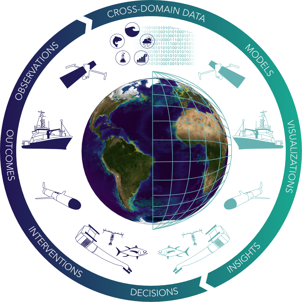
At GEOMAR, we are developing Digital Twins of the Ocean using a process-oriented and co-designed approach. Instead of building one large model, we create modular systems that reflect local needs and priorities. A key focus is the West African region, with its unique environmental and social challenges. These digital twins combine in-situ measurements, satellite data, and advanced models that link ocean physics, biology, and ecosystem processes. This helps us understand the ocean in a more comprehensive way—across different disciplines. To support these tools, we are upgrading the observation and research infrastructure around Cabo Verde. Long-term GEOMAR platforms are being improved to deliver real-time data, using advanced telemetry and a high-end buoy system. In addition, mobile and autonomous platforms will be used continuously to monitor the ocean. In addition, a key future initiative will be FUTURO, a one-year, interdisciplinary research campaign in the eastern tropical North Atlantic. It will bring together multiple research vessels and a large fleet of autonomous systems to study the dynamic upwelling region off West Africa. The campaign will collect high-resolution data, strengthen regional partnerships, and build knowledge for sustainable ocean use. The concept of the digital twins will turn this data into practical tools for marine spatial planning, sustainable fisheries, coastal protection, and biodiversity conservation. They will also support scientific experiments, education, outreach, and stakeholder engagement—helping to shape a new, inclusive way of managing the ocean in West Africa.
Imagine a world, where data and information can be easily and effectively shared, linked, transformed, and combined to answer future research questions and plan sustainable governance actions. Digital twins are one viewpoint from which to build the technologies needed to establish the required interoperability and transparency of data products and predition methods. This presentation will discuss corner stones of digital twins as well as mutual efforts growing from complementary viewpoints such as FAIR, data spaces and AI.
The growing interest in digital twin technology has excited numerous initiatives, also in the realm of the Earth system sciences; however, time-constraint funding often results in infrastructure solutions that, despite aiming for e.g. accessibility and interoperability, at worst remain effectively proprietary and centralized. This contribution proposes an alternative: a community-driven approach to building a digital twin of the ocean infrastructure that leverages already existing mature open-source technologies. Specifically, we advocate using Git repositories for the collaborative development of digital twin “apps” alongside Project Jupyter software, which provides interactive computing environments essential for handling heterogeneous data sources, exploring large datasets, and conducting numerical simulations. We also aim to stimulate a discussion about the need for bridging the gap between research data management and scientific computing -- an important step towards creating a sustainable, scalable, and performant digital twin ocean infrastructure that would foster human creativity, and accelerate knowledge generation and decision-making within what might be called a digital twin use case cycle.
In the past years, data driven machine learning models have revolutionized numerical weather prediction, outperforming traditional numerical models for the atmosphere both in efficiency and precision. Trained on reanalysis data, these models enable the generation of much larger simulation ensembles and, due to their differentiable architecture, offer new and efficient ways to directly integrate observational data. While data driven models are well established in atmospheric sciences, their application for the ocean remain in its early stages. In this contribution, I will present ongoing research in the Ocean Dynamics research unit to develop data-driven models for the ocean and sea-ice. I will highlight how these models could form the basis of a digital twin to merge model outputs and observational data and enables interactive, exploratory „what-if" simulations.
Marine ecosystems are under enormous pressure from anthropogenic activities. Adequate management and protection of marine ecosystems in the context of a sustainable "blue economy" requires that we understand where animals move, what habitats they need, and how their movements are affected by offshore developments. However, our knowledge is insufficient, even in well-studied systems such as the North Sea. Digital Twins (DT) can support our understanding of animal movements, by playing a key role in learning more about the functioning of our marine ecosystems, exploring future scenarios and supporting decision-making and policy development. Furthermore, the study of animal movements is currently undergoing a big data revolution and a wealth of data is now being obtained on the movements of animals underwater where individual animals can be tracked for years. The DTO-Track project will develop a prototype DT of the North Sea for animal movements. The project will use the European Tracking Network (ETN) database and other existing European DTO infrastructures such as EDITO-Infra to support the development of the DT. In addition, DTO-Track will coordinate the tracking of highly migratory species and provide new data for the DT, as well as mapping species movements and marine trends in the North Sea to identify overlaps. The DTO-Track project could have a lasting impact on the environment, economy and society by developing plans related to marine spatial planning, fisheries regulations, offshore development and energy and development policy in the North Sea.
The Western Baltic Sea (WB) is under increasing impacts from climate change and biodiversity degradation caused by eutrophication, pollution, increased land use and increased resource uptake. Between 1994 and 2019, WB has been overfished, leading to fish stock depletion of cod (Gadus morhua), herring (Clupea harengus), and sprat (Sprattus sprattus). The interconnected dynamics between cod-herring-sprat, where predator recovery can limit prey populations growth through trophic cascades, pose a challenge to predict management of these fish stocks.
We carried out model simulations using the OSMOSE multispecies model configured for the WB region and analysed the impacts of fishing and environmental pressures. By implementing various scenarios for fishing and environmental changes, sustainable management strategies could be suggested. Our analyses of fishing pressure scenarios revealed that there is a rapid decrease in all fish species present in the model, with the poorest recovery of cod stock, whereas environmental changes related to plankton availability, have the strongest effect on herring stock. The analysed impacts affect yield and biomass of the cod, herring and sprat, while also shifting the dynamics in their food web and altering fish size, weight and age class abundance.
Our research highlights, that sustainable management of WB fisheries requires species-specific strategies that account for different responses to changes in the ecosystem. OSMOSE Model output demonstrates environmental change vulnerability in WB fish communities and future effects of fishing pressure on fish and fisheries.
The ocean and its biodiversity are vital to life on Earth. Understanding their current state and how that state may change requires comprehensive data on biodiversity and related pressures. Protecting and restoring biodiversity is a key goal of the Horizon Europe Mission to restore oceans and waters by 2030, supporting the EU Green Deal and Biodiversity 2030 targets. A Digital Twin of the Ocean (DTO) is central to this effort, enabling simulations, advancing knowledge, and supporting policy and societal needs.
To accurately model ocean ecology, the DTO depends on continuous, accessible data on biodiversity and environmental pressures. While many actors collect such data and new technologies are emerging, much of the information remains inaccessible or fragmented, hindering the development of the DTO's biological component.
DTO-BioFlow aims to unlock and integrate these "sleeping" data flows using automated pipelines, feeding them into EMODnet and the broader EDITO infrastructure. By combining sustained data streams, models, and algorithms, DTO-BioFlow will build the biological layer of the DTO, delivering digital tools and services for policy and ecosystem management.
Through targeted use cases, the project will show the value of continuous biodiversity data for marine conservation and policy. Mobilising the marine biodiversity community, DTO-BioFlow will increase data availability and accessibility through 2030, directly supporting the Mission’s objective to protect and restore marine biodiversity.
With underwater noise pollution increasing globally—and formally recognized under the EU Marine Strategy Framework Directive (MSFD, Descriptor 11)—significant knowledge gaps remain regarding its effects on marine life, especially invertebrates. Addressing this requires monitoring and predicting the key elements of underwater noise, acoustic pressure and particle motion, while accounting for how these interact with abiotic changes like climate warming and ocean acidification across space and time. Detailed physical characterization of acoustic environments is crucial to recreate ecologically meaningful conditions in laboratory and field experiments. Yet equally important is understanding how marine organisms perceive and respond to noise. This receiver perspective is essential for defining dose-response relationships. A promising framework for noise monitoring in development by MSFD Descriptor 11 Noise Working Groups is the Level of Onset for Biologically Adverse Effects (LOBE). Defining LOBE demands species-specific threshold data, yet synthesizing diverse datasets remains a challenge. Our group conducts repeated soundscape recordings in the Wadden Sea, where complex hydrodynamics complicate data analysis—highlighting the need for automated approaches. From multiple sampling stations, we aim to develop sound propagation models that capture current acoustic conditions and enable future projections under varying environmental parameters in the future (e.g., temperature, salinity, pH, sediment, AIS data = noise). To determine biologically relevant thresholds, interdisciplinary research is needed—from behavioral and reproductive studies to molecular and neurobiological assessments. We focus on noise impacts on invertebrates and invite discussions and collaboration across physics, informatics, and biology to build a comprehensive understanding of underwater acoustic impacts.
The El Niño–Southern Oscillation (ENSO) profoundly influences global climate variability, with cascading impacts on regional precipitation, marine ecosystems, and socioeconomic systems. Reliable monitoring and early prediction of ENSO are thus essential for supporting next-generation ocean decision-making frameworks, including future Digital Twin of the Ocean (DTO) systems. This presentation introduces our recent efforts in developing satellite-based approaches for real-time ENSO monitoring and seasonal forecasting. Leveraging multi-source remote sensing data—such as sea surface temperature, outgoing longwave radiation, salinity, and wind—we have developed robust indices and machine learning-based prediction models, which showed promising performance during the 2023–2024 El Niño event. Although not yet implemented as an operational digital twin module, our work lays critical groundwork for future integration. In particular, we highlight potential interfaces with ocean-atmosphere coupling modules, climate impact assessment tools, and early-warning systems for extreme rainfall and typhoon risks in the Western Pacific. We aim to explore collaborations toward embedding these capabilities into a broader digital twin context and welcome exchange with researchers from physical oceanography, Earth system modeling, and socio-ecological disciplines.
Digital ocean twins (DOTs) are applications that bring together data and expert knowledge to support decision-making for sustainable ocean management. In the SEADOTs (Social-Ecological Ocean Management Applications using Digital Ocean Twins) project, we integrate social, economic, and ecological data with data on human activities, ocean data, ecosystem data, and a variety of models into DOTs. By creating and demonstrating applications in the Norwegian North Sea, the German North Sea and the Baltic Sea, each tailored to address distinct current challenges and developments, and simulating the interactions between human systems, human activities, and marine ecosystems, SEADOTs aims to facilitate and inform political decision making, marine spatial planning and adaptive management. SEADOTs’ ambition is to help safeguard ocean ecosystems, promote sustainable resource use, and enhance social and economic well-being.
Risk from climate hazards is commonly defined as the interplay of hazard, exposure, and vulnerability. In recent years, response capacity and adaptation have been recognized as additional dimensions in comprehensive risk frameworks. Digital twins offer a powerful approach to integrate all these components into one coherent and dynamic system. However, to adequately assess risk, digital twins must be supplied with high-quality, spatially detailed data on each of these components, including exposure.
One key exposure indicator is the spatial distribution of population and its future mobility. Given the high uncertainty surrounding demographic developments, population projections are typically based on different socioeconomic scenarios, such as the Shared Socioeconomic Pathways (SSPs). In this context, we have developed spatial population projections at a 1 km resolution for EU countries, derived from national projections aligned with the SSPs. To achieve this, we extended a flexible downscaling model that distributes national population projections to finer spatial levels using proxies of location attractiveness. This approach offers valuable insights into future population patterns and can be easily adapted to different scales or extended to include additional drivers of population movement. Furthermore, the model allows for the integration of vulnerability indicators, policy responses, and adaptation pathways, enabling a more nuanced understanding of how demographic shifts influence exposure and contribute to overall climate risk.
By embedding these spatial population projections into a digital twin framework, we enhance the ability to explore the uncertainty space of diverse future scenarios and support data-informed planning for climate resilience.
The EOM working group is engaged in the development of remote sensing-based evaluation algorithms for the analysis of terrestrial and aquatic ecosystems. We use different sensors to map coastal areas, and in particular shallow water zones, from cm to decameter scale. Examples are water depth, water constituents (e.g., Chl, TSM), benthos mapping (seagrass, macroalgae), floating algae or beach cast. I would like to present current projects and initiate ideas for further co-operation.
Coastal urban areas face increased risk from storm surge induced flooding due to accelerating sea level rise and continued urban expansion, without adaptation leading to exacerbated flood damages in the future. Thus, enhanced preparedness is essential to minimize damages, especially for coastal cities that have not yet adapted to the increasing risk. Despite their computational demands hydrodynamic models are an essential tool to simulate flood propagation and quantify flood exposure, due to their ability to accurately predict flood characteristics.
We have successfully validated a set of hydrodynamic models for several cities along the German Baltic Sea coast, using tide-gauge data and flood measurements collected during the storm surge in October 2023. In combination with synthetic but physically plausible storm surge hydrographs, available along the entire German Baltic Sea coast, our results can provide comprehensive insights into flood characteristics that support decision-making. For example, an automated set-up allows high resolution simulations of many events in relatively short time. Resulting flood characteristics can be compiled into probabilistic or digital portfolios of flood maps, helping identify areas at risk for multiple events, reducing uncertainties. Moreover, with the ability to simulate a large number of scenarios, we can support the evaluation of various adaptation strategies offering essential information on their effectiveness. Last, near real-time simulations enhance early warning capabilities and emergency planning. Integrating the above elements into digital twins and combining those with visualization techniques or AI models offers a promising foundation for operational frameworks in the face of increasing flood hazards.
This short presentation addresses one of DHI's decision support systems, BlueCast. This forecasting system is supported by several global metocean models and data sets to provide reliable assessments of wave, wind and currents at specific user-defined locations. With a multitude of applications oriented towards improving decision-making for and risk assessment of maritime operations, maintenance and safety, the symposium's audience will receive insights into a digital twin of the ocean and its subbasins that is an established out-of-the-box, marketable, commercial product.
Maritime transports are the backbone of global economics, while they account for 3% of global emissions. We report on research at DLR to support the shipping industry in increasing the safety of operations and, at the same time, reduce the carbon footprint of these operations. Digitalization and live integration of simulations with in-situ sensor data are key aspects to enable the use of new technologies in practical operation.
Exploring seafloor morphology and benthic habitats is essential for understanding the interactions between biology and geology. While findings have traditionally been shared through maps and graphs, effectively communicating environmental change and mitigation scenarios to stakeholders is becoming increasingly important. Immersive and dynamic environments offer a new way of transferring knowledge by enabling interactive discussions of science-based scenarios and the large, complex geospatial datasets used in ecosystem classification. However, integrating hydroacoustic or optical data into virtual environments often introduces artefacts, which limits their effectiveness. To address this issue, we have developed an asset-based, immersive, virtual model of a coastal land-to-sea (L2S) environment. This model focuses on coastal vegetation and the potential impact of sea-level rise on coastal landscapes. This is achieved through a combination of data acquisition and processing, semi-automated classification, and translation into the game engine Epic Unreal Engine 5. In this presentation, we will demonstrate such a dynamic virtual environment. We see a great potential of this method to visualize and explore complex virtual environments at the interface between terrestrial and marine datasets.
A good understanding of fluid flows inside the ocean is crucial to develop digital twins of it. In our new Laboratory of Numerical Mechanics and Flow Measurement Technology at the University of Applied Sciences in Kiel (FH Kiel) we are currently conducting measurements of fluid structures with optical measurement techniques such as Particle Image Velocimetry (PIV) and Temperature-Sensitive Paint (TSP) in order to validate our numeric simulations of fluid flows with Computational Fluid Dynamics (CFD).
The flow around different geometric objects, such as cylinders, flat plates and airfoils have been tested inside our FlowLab, a small water tunnel which has been specially designed for PIV measurements. In a recent experiment inside the FlowLab a flapping airfoil was tested to study vortex formation and visualization of unsteady fluid dynamics. In a different setup TSP was used to study vortex formation behind a cylinder and visualize the formation of horse shoe vortices. Together with the German Aerospace Center (DLR) the TSP technology has also been used to study the influence of steps and gaps on the location of laminar-turbulent transition on a flat plate inside a cryogenic wind tunnel.
Currently we are also conducting CFD calculations of wind turbine rotor blades in order to compare them with experimental measurements obtained with the help of an aerodynamic glove mounted to the rotor blade. This innovative approach of combining measurements with numeric calculations can also be promising for upcoming developments of digital twins of the ocean together with GEOMAR.
This presentation highlights the significance of storm surges in marinas on the Baltic Sea. It
uses the storm surge of 2023 as a case study and discusses the forecasting methods used
by the Federal Maritime and Hydrographic Agency. The speaker explains the mechanisms
of storm surges to improve understanding, examines the application of machine learning
techniques for storm surge prediction, and presents the data sets used. He addresses
challenges such as data volume and computational effort for training and validating models
and demonstrates the advantages of machine learning.
Over the past decade and together with a group of international collaborators, we have developed the Advanced Solver for Planetary Evolution, Convection and Tectonics (ASPECT, https://aspect.geodynamics.org/)—research software building on modern numerical methods and showing parallel scaling up to >100,000 compute cores. ASPECT has been widely used to simulate the Earth's mantle and crust, their interaction with the core, the surface, the oceans, ice sheets, and the atmosphere. We now aim to apply ASPECT to integrate models and data of the solid Earth into a unified digital representation, allowing us to put observations of Earth’s present and past into context—in particular, being able to accurately describe tectonic plate motion, deformation at plate boundaries and within plates, the response of the solid Earth to surface loads such as ice and water, and the participation of the solid Earth in the water and carbon cycles.
As a first step, we have developed global instantaneous 3-D mantle convection models with a heterogeneous density and viscosity distribution based on seismic tomography and weak plate boundaries inferred from a global fault database. Our model achieves a directional correlation to observed GPS data of 95.1%. Plate boundaries that are 3 to 4 orders of magnitude weaker than the surrounding lithosphere and low asthenospheric viscosities are a a requirement for the good fit. Our models emphasize the impact of plate boundary geometry on the direction and speed of plate motions and reaffirm the importance of slab pull in the uppermost mantle as a major plate driving force.